We Are In Uncharted Territory!
(July 31, 2017)
It was a long but very pretty run up from Cannery Cove to the small anchorage just inside the mouth of Tracy Arm. We caught another halibut bottom fishing on the way which was longer than our last one at 26”. The water and air got a bit colder as we got closer.
Meanwhile, I have been futzing with the Raspberry PI’s marine network stuff because the iPhone and Laptop show different positions compared to the chartplotter, and sometimes Navionics on my iPhone jumps around a bit between two positions. Anyway I was diagnosing it for a while and finally figured out that the GPS data coming from the chartplotter is 35-40 seconds behind, while the GPS data coming from the AIS directly is at real-time. So the chartplotter data stream (in the Raspberry Pi) shows where the boat was 35-40 seconds ago. I was able to filter the data in the WiFi stream so OpenCPN on my Mac and Navionics on the iPhone show the real-time GPS data from the AIS, but I’m not yet sure why the Chartplotter data is delayed. I may temporarily disable the newer GPS receiver I added to see if that’s the source of the delay, or if it’s something else in the system. But that’s something to do while anchored, not underway.
Speaking of anchoring, it’s increasingly clear that we need more anchor chain (or rode). We believe we have between 160ft and 180ft of chain, which is not enough to achieve the desired scope (4:1/5:1) in these deep anchorages we’ve been in. We are managing, but if there was a serious storm and we were stuck in a deep anchorage we could end up dragging anchor. We’ll have to deal with this when we get back to Anacortes.
As we approached the mouth of Tracy Arm, we saw a few icebergs floating outside, a few flanking the channel coming in, and a couple inside the anchorage. It was so strange to suddenly be gliding past these floating blue and white icebergs.
The anchorage at the mouth of Tracy Arm is beautiful. There are evergreen hills, snow-capped mountains, floating icebergs, birds, and seals. A couple of boats tried to chip iceberg ice off from a dinghy for cocktails, and I was able to get a few pieces into a cup with some bourbon, which was the longest lasting ice-cube I’ve ever had in a beverage. One boat pulled up an actual King Crab in their trap, the one and only catch of a King for the entire fleet on this trip.
On the morning of the 29th, the fleet departed our anchorage and motored up tracy arm, dodging small cocktail ice as well as larger bergs on the way. It was fun to name the shapes we saw in the icebergs we passed — submarines, swans, the Loch Tracy Monster, and so much more. We came in close to a large waterfall and got the drone out (in a little bit of rain) where I was able to capture 3 boats (including ours) crossing in front of the waterfall. Then I landed the drone back on deck relatively painlessly.
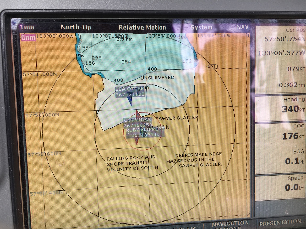
The ice path was pretty clear in general, we got within ½-3/4 mile of the face of S. Sawyer Glacier and floated freely with the ice for a while getting some pictures. Periodically, you could hear the ice thunder and see a small amount of calving. According to the charts we were literally in uncharted (unsurveyed) territory. The area was surveyed in 2004-ish and in the last 13 years the glacier has receded a long way. We were 1/2 mile from the glacier, but almost a 1/2 mile inland on the chart, well past the charted location of the glacier. Suddenly the sun came out, shining on the glacier and the wet glacier carved walls.
I fired up the drone again but really wasn’t paying attention to the fact that the boat was moving (under power), and it hit one of our mast shrouds during take-off and crashed to the deck from about 20 feet. It displayed a motor overload error and two of the blades were damaged so I replaced the blades and fired it back up, but it immediately flew backwards and crashed again. I haven’t attempted a take-off since then but the camera gimbal seems to be damaged, which is the overloaded motor it is alerting about, and the gimbal similarly won’t calibrate itself successfully. That’s 3 cameras down or degraded so far on this trip.
- The 18-200 VR lens for my Nikon DSLR was damaged when it was dropped on the cockpit floor. It’s jammed at 18mm. I have an 18-35 and 80-200 also, but neither are VR and 35-80 is a bit, very useful, gap I don’t have a lens for.
- The Nikon waterproof camera we have probably works fine, but somehow it’s charger didn’t get on the boat, or we just haven’t found it yet, so we can’t charge it/use it.
- Today’s drone issues put the drone out of commission.
We still have the working lenses on my Nikon DSLR, the VIRB XE (Garmin’s action camera), and and two older Canon PowerShot Elph’s I’ve had for a long time. We also have our iPhones of course, so not all is lost. We even have an underwater case for one of the old PowerShots.
The water temp was coldest we’ve ever seen, 49F, and the air off the glacier was cool as well.
I checked satellite email and got a notice that we’d used 15MB. WAIT! WHAT!? Our monthly plan includes 6MB and I’ve been monitoring it pretty closely so we shouldn’t be anywhere near 15MB. I turned it off, then later fired it back up to see if I could figure out how we are using that much. It seems that even if nothing is being uploaded/downloaded, something (I believe the satellite firewall itself is constantly polling something, keeping the connection alive and also burning data. The satellite box does show we used 15MB so far, but while doing absolutely nothing, I see the counters incrementing every second. I powered it off again for now and the plan is to power it on each time we want to use it, then off again. But this means the phone is not ready for an incoming call most of the time. Another thing to deal with soon.
Morgan and Ellie got in the kayak and explored for a few minutes, but Morgan skipped lunch which can cause problems, so inevitably she stopped listening to us and wouldn’t come back when asked, turning it into a bit of a safety problem with the ice floating all around the boat. We managed to retrieve her and get the kayak back to the boat but she was not a happy camper. It really got me down after what was a really spectacular day, marred by a couple technical glitches and a final family blow up.
Hours later Morgan still hadn’t eaten and basically refused to. She had to be crazy hungry, I don’t get it. by 5:30pm, she still hadn’t eaten her lunch that we left out, and then asked for hot chocolate, which she did NOT get since she had, at this point, eaten no food since 8am. She was upset about this development as well and hid in her bunk. We know that she get’s hangry (hungry-angry) if she hasn’t eaten and today was yet another day where we let her have her fun without eating first and it blew up in our face. We just need to be more diligent going forward. In the meantime, Morgan has lost her solo kayaking privileges for a while.
We motored back to the previous night’s anchorage at the mouth of Tracy Arm, during which time it rained heavily for a while. The fleet planned a sushi potluck/party, Ruby Slippers, Lori Lee (a beautiful 49ft American Tug), and Zephyr (the sleek Sweden 45) rafted together for the party and we dinghied over (actually we were too lazy to put the motor on the dinghy so Stan from Breakaway towed our dinghy with his.) Devon supplied boat-made Miso soup to accompany the wonderful sushi rolls with halibut, salmon, prawns, crab, and roe. Of 12 boats, we were the only ones with Miso paste. m/v Lori Lee (who own a hereferd cattle ranch in Alabama) made BBQ chicken drumsticks which was a welcome change from the nearly 100% seafood diet we’ve been having.
Tomorrow we head south for the first time on this trip, marking the official start of our return from SE Alaska.


